

|
Products
|
| GSC |
| DSS |
| GSPC |
|
Science
|
| Data Access |
| Related Science |
|
Missions
|
| HST |
| GEMINI |
| VLT |
| NGST |
| Virtual Observatory |
| XMM |
|
Facilities
|
| Plate Scanning |
| COMPASS ooDB |
| Staff Pages |
Last Updated Jan 2001
Copyright © 2001 The Association of Universities for Research in Astronomy, Inc. All Rights Reserved.
|
About
|
Help |
About Show Sky
Show Sky is a Java based tool for querying point source catalogues and image archives. It has been specifically developed to assist in the quality control of the GSC2 catalog production. The tool allows for plotting of multiple catalogs over multiple images. Images can be flicked between or alpha blended into a single image. One unique feature of Show Sky is the ability to animate proper motions. Below is a screen shot of the application showing some proper motions..

Another unique feature of show sky is the ability to plot Hierarchical Triangular Mesh fields over the field and give HTM numbers at the current mouse position the HTMPanel is shown below over a field with HTMs plotted on it.

| Arbitrary colour texture maps may now also be plotted with stsci.sky.ShowFullSky this reads a set of intensities from a file and generates a colour image such as shown opposite. This is a rather new and fairly untested feature. | 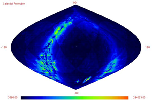 |
Work on the tool started around the same time as the JSKY initiative and uses similar technology such as Java Advanced Imaging (JAI). The initial concept came from the ESA's Hipparcos catalogue viewer/animation applets.
All source code for ShowSky are available on the download page.
ShowSky User Guide is available online.
ShowSky Java Docs for developers are available online.
HTMIndex Java Docs are available online.