|
Products
|
| GSC |
| DSS |
| GSPC |
|
Science
|
| Data Access |
| Related Science |
|
Missions
|
| HST |
| GEMINI |
| VLT |
| NGST |
| Virtual Observatory |
| XMM |
|
Facilities
|
| Plate Scanning |
| COMPASS ooDB |
| Staff Pages |
Last Updated Jan 2001
Copyright � 2001 The Association of Universities for Research in Astronomy, Inc. All Rights Reserved.
GSC2 Export Catalog 2.1.1 Release NotesThe data access and format has been preserved from the previous 2.1.0 release. Some of the information contained herein is repetitive of the previous release, but with some improvements on level of detail.
General Description
Data Access Software
Export Catalog File Format
FITS File Internal Structure
Primary HDU
HDU 2, ASCII Table
HDU 3, Export Binary Table Fields and Types
FITS HDU 3 Entry Description
Future Release Enhancements
Classification Codes
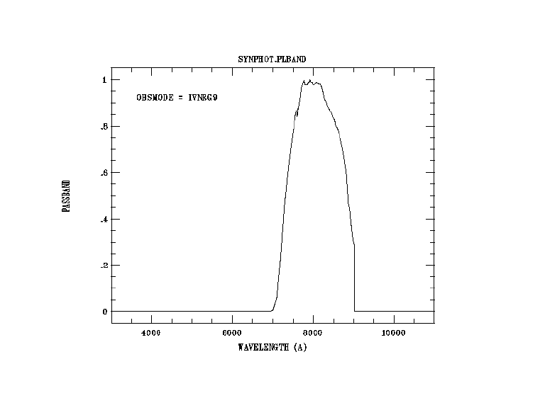
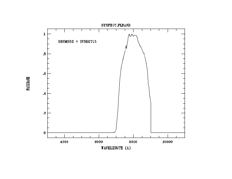
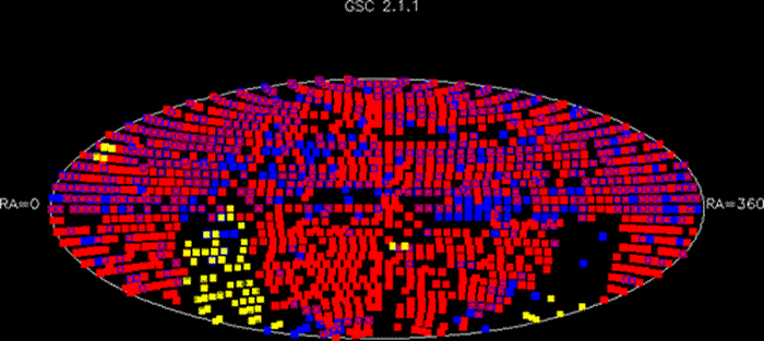
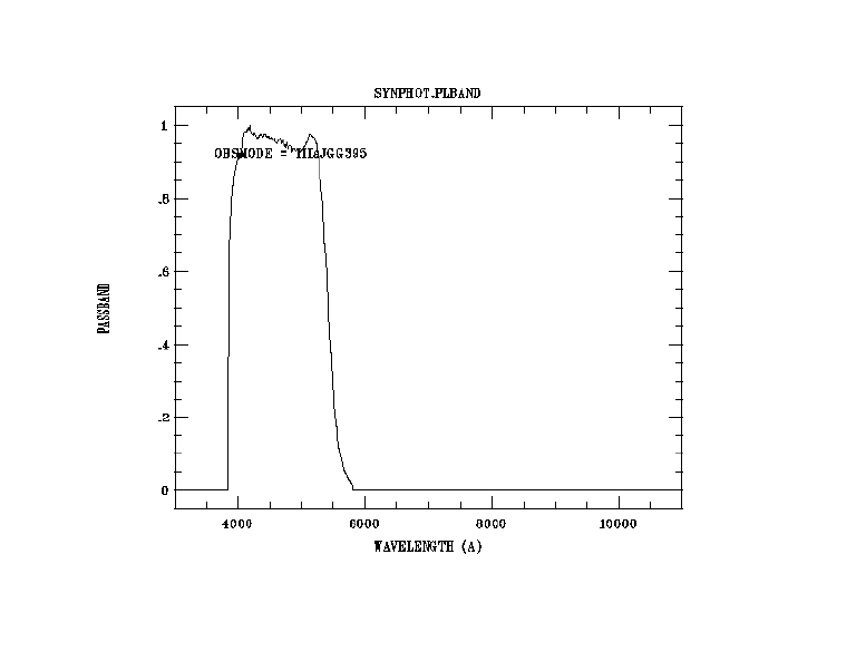
Transmission CurvesGSC2.1.1 is the export of 1893 calibrated digitized survey plates from the COMPASS database. The number of source positions exported is approximately 399.4 million, with some of these containing multiple bandpasses. The COMPASS database now contains over 1.1 billion observations. The storage capacity required for GSC 2.1.1 is approximately 56.1 GB. The sky coverage contained in this release is graphically illustrated here. XP, ER, and XS are plotted in red, XJ, or S plates are plotted in blue, and the remaining short and intermediate exposure plates are plotted in yellow. For the corresponding export plate list which contains the specific plate survey regions and J2000 central coordinates for this release, see GSC2.1.1 Export Plate List.
Return to top.
This software is currently only for specialized distribution to the GSC-II consortium. A C++ cgi script has been developed for integration into telescope observation tools consistent with the standard interfaces used with SkyCat. Public distribution will be made available end of year 2000.
Return to top.
The export catalog is a distributed FITS file system based on the linear quad-tree Hierarchical Triangular Mesh (HTM) sky partitioning scheme (see HTM Reference ). GSC-2 catalog uses a level 6 HTM triangulation which results in each file containing roughly 1 square degree of sky data. The source numbers per file are not balanced at this time, but future options are available to extend this capability into the HTM access methods.
Return to top.
Each FITS file contains all calibrated celestial sources for a single triangular section of sky (HTM level 6 leafnode). The file names are the quad-tree representation of each triangular section, with the 1st character being either an �N� or �S� representing North or South.
A FITS file contains 1 primary HDU, a second HDU (1st extension) ACSII table, and a third HDU (2nd extension) binary table. HDU 2 is a fixed length 256 entry lookup table into a variable sized HDU 3. The HDU 3 is sorted into HTM level 10 cells, and thus the lookup points to the first record of each level 10 cell with the number of entries in that cell also included in the ASCII table. The level 10 provides an indexing resolution of approximately 18 square arc minutes.
Return to top.
The default settings were used in some preliminary exports, but there are a set of standard keywords that will be available in next release.
Return to top.
Variable Type Variable Name Description Integer tfields=2 "Table fields" The table will contains 2 columns. Long nrows=256 "Number of Rows" Table will have 256 rows. Char extname[]="HTMLevel10Idx" "Extension name" Name of the extention. Char *ttype[]={"Freq", "L10Pointer"}; "Table Type" Char *tform[]={"I10","I10"}; "Table Form" Char *tunit[]={" "," "}; "Table Unit" Return to top.
HDU 3, Export Binary Table Fields and Types
Field Type Form Unit 1 GscID2 J id 2 RightAsc D rad 3 Declination D rad 4 MeanEpoch E 5 RaEpsilon E rad 6 DecEpsilon E Rad 7 RaProperMotion** E mas/yr 8 DecProperMotion** E mas/yr 9 RaProperMotionErr** E 10 DecProperMotionErr** E 11 Fmag E mag 12 FmagErr E 13 Jmag E mag 14 JmagErr E 15 Vmag E mag 16 VmagErr E 17 Nmag E mag 18 NmagErr E 19 Classification# J 20 SemiMajorAxis*** E pixels 21 Eccentricity*** E 22 Positionangle*** E deg ** Available with release GSC2.2
*** Not available for GSC1.2 entries
# See Classification Codes table belowReturn to top.
GSC-2 is exported from the COMPASS object-oriented database which contains all calibrated photographic plate data as well as a master ObjectIndex, the source cross-referencing of all overlapping plates and external reference catalogs. Each source has been observed on multiple plates at multiple epochs (including the POSS-I plates) and therefore may have one or more observed magnitudes from varying plate bandpasses. The export catalog magnitudes are calibrated by the plate processing pipeline in the natural bandpass of the plate and are mapped into F, J, V or N bands. A set of transmission curves are included below. The exported coordinates for each source correspond to the first detection of each source. Notice that the last 3 fields are null (0) for sources that were not processed through the pipeline, i.e. GSC1.2 detections.
Return to top.
- Grouping of magnitudes into F, J, V, and N will have higher selectivity of observations based on bandcode.
- Positions will be statistically optimized and coordinate errors will be available.
- Proper Motions will be computed for multi-epoch sources.
- Table entries will be reviewed, possibly expanded.
- Public cross-access to COMPASS observations will be possible (ShowSky JAVA tool alpha version 2.0 released).
- Full suite of classified objects (see codes for future availability)
Return to top.
0 Star 1 Galaxy 2 Blend 3 Non-Star 4 Unclassified 5 Defect Return to top.
Transmission Curves


Return to top.