|
||||||||
|


| About Us |
| Sky Surveys |
| Catalogs |
| Software |
| HST Support |
| Related Sites |
GSC 2.2 Release NotesThese notes contain basic information about the GSC2.2 catalog content, format and data access methods. Several new fields are provided with this release including proper motions, additional magnitude columns, and identifiers.
General Description
Source Counts
Catalog Fields
Data Access Software
Export Catalog File Format
FITS HDU 2, ASCII Table: HTM Level 10 lookup
FITS HDU 3, Export Binary Table Fields and Types
Future Release Enhancements
Classification and Source Status Codes
Known catalog limitationsGSC2.2 is an all-sky export of calibrated photographic survey plate source parameters from the COMPASS database. All sources exported are from the second-generation plate-processing pipeline with the exception of Tycho-2 and Skymap sources in the case of very bright objects. The Skymap sources are exported when there is no matching GSC or Tycho sources.
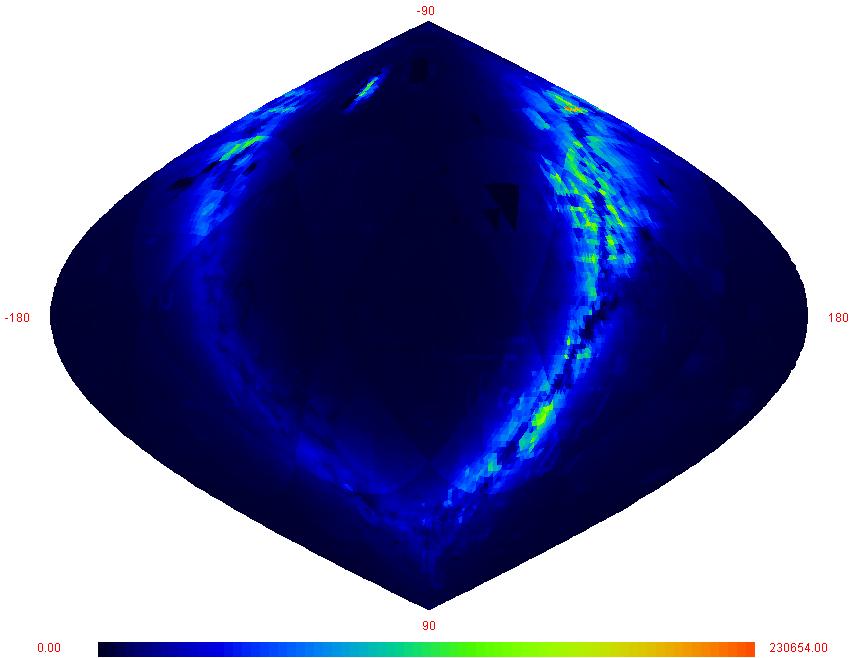
The number of unique objects exported is approximately 997,028,547. The catalog properties for this release represent a magnitude-selected subset of the full COMPASS database. The storage capacity required for GSC 2.2 is approximately 40 Gigabytes. Below is an all-sky map of the object density per square degree for this export.
Each GSC 2.2 contains only one position and one magnitude per bandpass for each unique sky object. To maximize the quality of the exported data the catalog parameter selection was performed as follows:
- Positions and magnitudes from plate observations were selected by choosing the observation which occurs closest to the plate center. Position selection was then prioritized by
- Magnitude cutoffs were applied (F=18.5, J=19.5, V=19.5) before position selection.
- If an observation occurred at different plate scanning resolutions, the highest resolution (15 um pixels) was selected over the lower resolution (25 um pixels) for each bandpass regardless of plate location.
- Star/nonstar classifications were assigned by voting all available classifications from 15um scans, before applying the magnitude cutoff. Classifications from 25um scans were used only if no 15um data were available for the object. Ties were broken in favor of nonstar, and defect classifications were considered to be nonstellar for matched objects. Unmatched plate defects were excluded from the catalog.
Return to top.
For this release, the main public access supported is through the GSC-2.2 Web form interface. The underlying software is currently only for specialized distribution to the GSC-II consortium until the final 2.3 catalog calibrations are completed. A C++ cgi script has been developed for integration into telescope observation tools consistent with the standard interfaces used with SkyCat. There is a Beta version of ShowSky visualization tool , a JAVA application available to the public which query access to GSC-2.2, DSS, and various other catalogs .
Return to top.
The export catalog is a distributed FITS file system based on the linear quad-tree Hierarchical Triangular Mesh (HTM) sky partitioning scheme (see HTM Reference ). GSC-2 catalog uses a level 6 HTM triangulation which results in each file containing roughly 1 square degree of sky data. The source numbers per file are not balanced at this time, but future options are available to extend this capability into the HTM access methods.
Each FITS file contains all calibrated celestial sources for a single triangular section of sky (HTM level 6 leafnode). The file names are the quad-tree representation of each triangular section, with the 1st character being either an 'N' or 'S' representing North or South.
A FITS file contains 1 primary HDU, a second HDU (1st extension) ACSII table, and a third HDU (2nd extension) binary table. HDU 2 is a fixed length 256 entry lookup table into a variable sized HDU 3. The HDU 3 is sorted into HTM level 10 cells, and thus the lookup points to the first record of each level 10 cell with the number of entries in that cell also included in the ASCII table. The level 10 provides an indexing resolution of approximately 18 square arc minutes.
Return to top.
Variable Type Variable Name Description Integer tfields=2 "Table fields" The table will contains 2 columns. Long nrows=256 "Number of Rows" Table will have 256 rows. Char extname[]="HTMLevel10Idx" "Extension name" Name of the extention. Char *ttype[]={"Freq", "L10Pointer"}; "Table Type" Char *tform[]={"I10","I10"}; "Table Form" Char *tunit[]={" "," "}; "Table Unit" Return to top.
HDU 3, Export Binary Table Fields and Types
Field Type Form Unit 1 gscID2 J id 2 RightAsc D rad 3 Declination D rad 4 MeanEpoch E 5 RaEpsilon E rad 6 DecEpsilon E Rad 7 RaProperMotion** E mas/yr 8 DecProperMotion** E mas/yr 9 RaProperMotionErr** E 10 DecProperMotionErr** E 11 Fmag E mag 12 FmagErr E 13 Jmag E mag 14 JmagErr E 15 Vmag E mag 16 VmagErr E 17 Nmag E mag 18 NmagErr E 19 Classification J 20 SemiMajorAxis E pixels 21 Eccentricity E 22 Positionangle E deg 23 Source Status Flag J ** Available with release GSC2.3
Return to top.
- Proper Motions will be computed for multi-epoch sources.
- Full suite of classified objects (see codes for future availability)
Return to top.
0 Star 1 Galaxy 2 Blend 3 Non-Star 4 Unclassified 5 Defect Return to top.
The source status flag is a 10 digit field used to encode more detailed information about the properties of the catalog object and its calibrated values. Since no GSC-II processed data is included for Tycho or SkyMap objects, the value of the Source Status Flag for a Tycho object is 99999900, Skymap is 88888800.
0 Barycenter 4 multicircular 1 Circular Gaussian 5 multielliptical 2 Elliptical Gaussian 6 FPA + circular 3 FPA-applied barycenter 7 FPA + elliptical
Return to top.
|